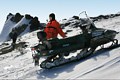
Combined Tour (Rafting + Caving trip) on the River Yuryuzan
Only people who have visited the area of the river Yuryuzan and seen its stonewalls with caves and grottoes, floated on the blue ponds and admired its fords, can appreciate this majestic beauty.
We invite you to go together with us on this fascinating tour on the most picturesque section of the Yuryuzan, between Ust-Katav and Verkhnyaya Luka (“luka” – “bend of river” in Russian language) and visit some very interesting local caves: Idrisovskaya, The Salavat Yulaev’s Refuge, Ignatievskaya, and also the Serpievskii cave complex.
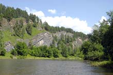 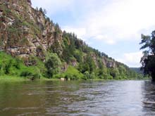 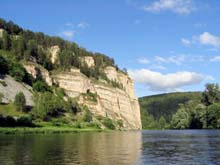
Our rafting begins from the railway station at Ust-Katav, Chelyabinsk district, near where the river flows in a narrow valley (width is 30 - 35 m) with high rocky banks, covered with forest. On the banks we see rocks with unusual shapes, looking like medieval castles with fortifications, towers and loopholes, giving the river a fascinating beauty.
Near Ust-Katav station, the rock "Sabakai", which contains three caves of karst origin, rises abruptly up to a height of 90 m above the smooth surface of the river.
In the first (biggest - length 146 m) cave, we see signs of primitive men from the Neolithic age and bones of extinct animals. In spring and autumn the "Sabakai", covered with trees and bushes, is surprisingly beautiful.
To the north from the station (about 4 km) the caves: Ust-Katavskaya (length 220 м) - famous for the paleontological finds of early Paleolithic times - bones of the mammoth, woolly rhinoceros and cave bear, the Verkhnyaya Provalnaya - giving a rare opportunity for us to go in an underground water channel of karst origin and the Minkskaya cave are situated.
Near the village Idrisovo we stop for a day’s rest at “Idrisovskaya” on the left bank of the river and visit the 93 m cave Idrisovskaya (named after the village Idrisovo) and others such as – Kisyatash, Palace, and Krasnopolskaya, located 1.5 km to the southeast from the village. Idrisovskaya is protected by the state as a historical, archaeological and natural monument. The cave was formed in dark grey limestone beds of the Lower - Middle Carbonic age. The earliest description of the cave was made by the head of the expedition of the St.-Petersburg Academy of sciences - the scientist, geographer and traveller Pallas Peter Simon, during his visit in 1770.
As the numerous Bashkir legends say, in an autumn of 1774, in this cave was the refuge of Salavat Yulaev, who was the national hero of Bashkir people. He took part in the country revolt, fighting against the Russian Empire under the leadership of Emelian Pugachev in 17th century and later hid in the environs of the Yuryuzan after revolt was annihilated.
The rectangular entrance to the cave has a width of 2.4 m and height of 3.8 m and is situated 45 m above the river. In clay earth from the cave, archaeologists found bones of animals, wood and remains of vegetation. Behind Verkhnyaya Luka the river flows along the right slope of a hilly valley “Maloyazskaya” (named after the village Maloyaz) where the river makes a bend. On the left flat bank of the river spread small villages, meadows and coppices.
On the right bank of the river to the southeast of Maloyaz, the 54 m cave “ Salavat Yulaev’s Refuge” - the historical monument of the Bashkir people, is located. The cave was formed in limestone beds of the Lower- Middle Carbonic age. The cave contains a bent gallery, extending in a southerly direction with a small grotto at the end, where the direction of the cave changes from the south to the north. 5 m from the entrance there is a glacier with an area of 30 sq. m - here snow remains almost until the end of summer.
Further, on the right bank, the famous health resort Yangan-Tau is situated on the slopes of Mt. Yangan-Tau (“burnt mountain” in Bashkir language). The mountain is located at the crossing point of large tectonic structures of the earth’s crust. Here our rafting comes to a conclusion.
More than 200 years ago it was observed that hot water gases and gas emissions were discharged from cavities on Mt. Yangan-Tau. This thermal phenomenon was considered as a miracle and cured many from illnesses - among the mineral water springs are fresh and salt water, some sulphurous and one radon. People visit the thermal spring Кurgazak with its curative mineral waters, when staying at the health resort Yangan-tau for medicinal purposes. It is a spring with warm, mildly radioactive, mineral water with a low content of radon.
The temperature of the inner part of Yangan-Tau is about 380OC, while throughout the year the temperature of the spring water is +16-18 OC. Even in a severe winter the water doesn’t freeze. It is also possible for us to visit “Kuselyarovskij” - a sulphur spring with a water temperature of +18-20 OC. Water of this spring contains gases of hydrogen sulphide, hydrocarbons, nitrogen, argon, and helium. Near the spring, organic material, which has curative properties and has been used in “mud treatment”, has been accumulating.
After our fascinating travel we will visit a unique cultural-historical and archaeological monument of the southern Urals – Ignatievskaya cave. The first mention of the cave was made by the founder of the study of local lore in the southern Urals, the professor of the St.-Petersburg Academy of sciences, Petr Rychkov, in his book “Topography of the Orenburg district”, written in 1755. Almost two hundred years later, the rock paintings, which are about 14 thousand years old were found. These paintings (12 groups) are represented by the figures of primitive men, animals, during various stages of hunting. In recent years Ignatievskaya cave with its rock paintings became the most visited object among the caves of this area.
Also we will visit the Serpievskij cave complex, situated not far from Ignatievskaya in the valley of the river Sim near the village Serpievka in the Katav-Ivanovsk, Chelyabinsk district. The cave city stretches15km along both sides of the upper reaches of the river Sim. Almost all forms of karst relief are found here. There are vertical, horizontal and labyrinth caves, karst arcs, niches, awnings and grottoes, karst craters, underground rivers, lakes and springs. All of these together, in a united complex, are an absolutely unique sample of karst landscape. In many caves signs of primitive men and remains of extinct animals were found.
Extent - 105 kilometres.
Optimum time for tour: June - August (September).  
|