Rafting on the River Chusovaya, Middle Ural
The left tributary of the river Kama,- the Chusovaya - one of the large and most beautiful rivers of the Urals. The river was probably named from the translated word "chus-va" – “rapid water” in Komi – Permian language.
 The river has a unique feature - it flows on two continents - Asia and Europe, originating on the east slope of the Ural ridge, crossing it and then flowing on the western slope. From ancient times the river Chusovaya was used as trade route between Europe and Siberia. The river has a unique feature - it flows on two continents - Asia and Europe, originating on the east slope of the Ural ridge, crossing it and then flowing on the western slope. From ancient times the river Chusovaya was used as trade route between Europe and Siberia.
The Chusovaya was first mentioned in written Russian documents in 1396. From the16th century Russians began making the river Chusovaya navigable. In 1558, according to the edict of tsar Ivan IV, merchants of the Stroganov family received sole possession and control of the river within the boundaries of the upper and middle Kama and its associated tributaries on a never-ending basis. In 1568 these merchants were also given full control over the “country Chusoviya” (from the mouth of the Chusovaya to the upper reaches and up to 21 km from its banks).
At the end of the 19th century the famous Russian writer, D.Mamin-Sibiryak wrote, “The River Chusovaya, probably, will be in a short time one of the favorite places for Russian tourists, scientists, artists... In the future, tourists will rest in these mountains and forests, artists will find plentiful material for their works and scientists, will undoubtedly, find a lot of interest in geology, botany and ethnography... ”. In reality, the river became a treasured dream for many Russian tourists.
It flows on the territory of three districts - Chelyabinsk, Sverdlovsk and Perm rising from the northern part of the Chelyabinsk district. Its middle section crosses the border between Sverdlovsk and Perm twice then flows into the Kama reservoir near the city of Perm. The length of the river is 777 km and the area of its basin is 42,000 sq. km.
The Chusovaya is “opened” at the end of April, when the ice quickly melts and the water level rises 3-4 m. In the summer months the river becomes very shallow – at the end the July to the beginning of August the depth on fords does not exceed 7-15 cm. In autumn the weather is rainy and the water level rises considerably and then in November the river freezes. The average height of the river is 120-250 m above sea level.
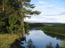
On banks of the Chusovaya, different species of trees grow - fur-trees, firs, pines, larch, birch and aspen. The forest is rich with berries and mushrooms. It is possible to see elks, bears, wolves, lynx, foxes, hares, squirrels and chipmunks. There are also many heath cocks and hazel grouses. In autumn on the river, migratory birds, such as ducks and geese rest. In the river different species of fish are found - perch, ruff, small fry, pike, chub, ide (from the carp family) and bream.
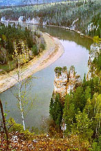
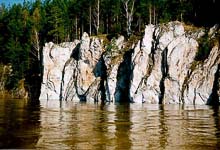
Limestone and dolomite rocks with amazing shapes on the banks give the river a fascinating beauty. In middle part of the river there are about two hundred rocks. These rocks on the Chusovaya are named “Kamien” and the"Boets” (Fighter) was the most dangerous for barges, which traveled down the river in olden times. The rocks vary in height from 10 to 115 metres above water level and stretch from 30 metres to 1.5 kilometers along the banks. All of the rocks have a karst origin and in some of them are small caves. Many of these rock formations are protected by the state as natural monuments.
Rafting along the river Chusovaya
Duration - 4 days
Tourists begin their fascinating travel down the river from the tourist base “Chusovaya”, located in the ancient village Sloboda.
Sloboda was founded in 1651 on land between the rivers Chusovaya and Utka. The fortress protected Russian settlements and trading caravans on the Chusovaya. In 1652 it consisted of 50 courtyards and was enclosed by a wooden paling fence with two watchtowers. The need for protection soon disappeared, and inhabitants began to settle on both banks of the river. In 1703 according to a decree of tsar Peter the Great at the mouth of the river Utka, the first state quay for sending iron production from the Ural factories to Moscow and St. Petersburg along the river Chusovaya and further along the rivers Kama and Volga was built. Originally production from factories in Neviyansk, Alapaevsk, Kamensk, and Uktus was sent to Sloboda. In the second half of the 18th century the quay was named “Turchaninovskaya”, after the merchant Turchaninov’s family who owned Sysert metallurgical factories in the middle Urals and consequently goods from Sysert were also sent via this quay.
Founded on October 29th 1934, on a rocky bank of the river on the rocks “Sobachie Gebra” (“the Dog Ribs”) is the first tourist base in the Urals, “Chusovaya”. Here the rafting part of the tour begins.
After the first turn of the river the village Sloboda gradually disappears and we reach a range of rocks - Georgievskie. Behind them is the rock “Chasovoi” (Sentry).
Several kilometres downstream on cliffs on the left bank, spreads the small village Kamenka. It was based as a fortress in 1574 and was the most eastern settlement in possession of Stroganov’s merchants in the 16th century. During the years 1726 - 1729 this small village became a large shipyard, building wooden barges, which were sent for loading at the quay “New village” (“Lower Village”). A large saw mill was built at the base of the shipyard providing Utka state with lumber. Below the mouth of the river Kamenka (tributary of the Chusovaya), the river Chusovaya flows for several kilometres almost rectilinear.
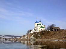
Then ahead you will see the island with the century old poplars, picturesquely towering among bushes and green grass. Behind the island the “Lower Village” begins. On the left bank towers the church, erected in the classic style between the years 1855 -1860. Other similar constructions of wooden architecture were not kept in another settlements on the river Chusovaya. The “Lower Village” was named because of its locality behind the quay “Kamenskaya”.
In the river-channel near the village there are some islands, divided by very shallow channels. Rafting by the rock “Shaitan Kamien” (“Evil spirit”), it is possible to see the marks dated “1911” - year when one of the first expeditions marked the water level trying to find a waterway across the Urals.
Further, after a turn, the Chusovaya flows by the rock “Senkin Kamien” rising abruptly up to height of 25-30 m. Not far from here, on the same bank, is the rock “Visyachii Kamien (Steep Rock), then for a 2km stretch downstream the river is very calm. Appearing after a turn, resembling a large overturned clay pot is the rock “Kamien Korchagi” (Earthenware Pot Rock). Then a suspension bridge is seen ahead. Behind the bridge is the mouth of the river Treka. On the right bank, 300 years ago, the village bearing the same name was established. There was a quay here, where wooden barges were built and loaded, but it was not kept.
Behind the rock “Kamien Boyarin” (Russian Noble Rock) is the big island. Later we will be attracted by the unique and beautiful rocks “Grebeshki”, which stretch up to kilometre along the bank. “Grebeshki” looks like large ribs or thin vertical plates. On the upper parts of some rocks you can see pointed peaks and “whimsical turrets”. Where “Grebeshki” ends there is an island, behind which, on the right bank, we see the majestic rock “Siberian Kamien”.
Then on the left bank rises the grandiose “Zaplotnyi Kamien” - a grey 35-metre stonewall. In the early morning, when covered by sunbeams the rock is especially beautiful. Rafting by the rock “Blue Kamien” it is necessary to be particularly attentive, as here in the river-channel there are reefs - many of which are imperceptible and dangerous for rafting. At this point the rock “Kamien Swan”, a continuous 200 metre stonewall, is seen in the distance. In olden times, during spring, “Kamien Swan” was considered dangerous for barges laden with goods.
The river turns to the left, and we see the rock “Vinokurennyi Kamien” (“Distilling”). This rock stretches along the left bank 400 m, like a stonewall with a height of 45 metres - rising steeply from the water, then departing from the bank and forming a broad gully covered with forest. From the top of the rock it is possible to see the village Kuriya and the highest mountain Sabik (531 м). Behind Vinokurennyi Kamien, far from the bank, the rock “Kurijinskii Kamien” (named after the village Kuriya) is seen. Directly behind it the village Kuriya spreads over both banks. One more turn and the largest working settlement on our route, Staroutkinsk (In the old days it was village “Old Utka”) comes into view. Akinfii Demidov founded “Old Utka” in 1729 in conjunction with the construction of a metallurgical factory - one of the “first-borns” of the mining and metallurgical industry in the Urals. The river Utka was partitioned off by a dam, above which the Staroutkinskij pond was formed. Hitherto the unique old blast furnace still works. In the settlement the complex of buildings, which were constructed at the basis for the factory are preserved. On the Chusovaya near the village “Old Utka” one of the largest quays was built. Each spring from this quay barges loaded with Ural metal were sent downwards.
Behind the rock “Bratnin Kamien” (Brother Rock) the beautiful rock “Visyachii” is seen. Below the last rock we see the rock “Dyrovatyi” with several hollows of karst origin on its surface. From the rock “Yamnyi Kamien” (Deep Pool Rock) the Chusovaya turns to the east and on the left bank, hanging above the water, looking like a bird with folded wings is the 25m rock “Kamien-Sokol” (“the Falcon”). Ahead is the rock “Kamien Balaban” with a height of 40 м.
We next see the rock “Russian Noble”, looking like a triangular Russian noble’s cap. Behind it is “Kamien Maksimovskii”, which is suspended above the water by a multi ton block. The undermined base of the rock creates an impression of instability. On the right bank is the 60m “Mosin Kamien”. It is one of the most majestic rocks on the Chusovaya and it is possible to climb to the top.
From here we can see the next section of the river along which we will be rafting - on the left bank in a forest, three white rocks “The Ships” and the village Chusovoe are seen. Chusovoe, referred to earlier as the Shaitanskii factory (“Shaitanka”), was founded by Akinfii Demidov in 1727. The force of falling water from a dam on the river Shaitanka drove the mechanisms of the metallurgical factory, but now only the dam reminds us about the former factory. Local inhabitants have pride in the art gallery, where there are more than 300 works by Ural artists. The gallery is in a two-storied building - the former house of the factory’s office manager. On the ground floor, display-windows featuring historical exhibits, photos, and a description of the history of the village Chusovoe are presented.
 
|