Combined Tour (trekking + rafting) in the Northern Urals
Duration - 12 days
Optimum time for tour is July - August.
The average temperature in July is +16°C.
August is the most preferable month, as there are almost no mosquitoes.
During the rafting: fishing – catch grayling (up to 1 kg).
Especially for you during the tour the tourist "banya" (bath) will be organized.
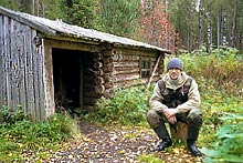
Accommodation: Tent camps.
The tour is conducted on the western slopes of the northern Urals on the border of Perm and Sverdlovsk districts and the territory of Krasnovishersk. Several mountain ridges, extending in a sub-meridianal fashion, cut narrow valleys of the numerous rivers forming the local relief.
This region in the northern Urals has broad river system with all rivers and streams connected to the basin of the river Vishera. The rivers differ in character of channel, current and morphology of banks but most are shallow and slow, without rapids or large reefs. Only in the upper reaches of the rivers Vishera, Moiva and Acchim (the tributaries of the river Vishera) are there rapids and fords with beautiful picturesque rocks with heights up to 100 m. on the banks.
Except for the alpine part, most of the region is covered with coniferous forests (fir, rare pine, larch and cedar). Pine forests are basically situated in sandy soil on high old terraces and watersheds.
The area is rich with mushrooms and berries – more than 10 edible species - among them bilberries, blueberries, cloudberries, raspberries, currents, cowberries, wild strawberries and stone berries.
The fauna of area is rich and diverse. There are about 40 species of animals - white hair, squirrels, foxes, martens, wolves, glutton (wolverine), bears, elks, chipmunks, muskrats, otters and others, 16 species of fish - taimen, grayling, sig (freshwater fish of the salmon species), burbot, small fry, ide, carp, gudgeon and others. It is possible to see many bird species– cedarbird, wood grouse, black grouse, hazel grouse, white partridge and tundra partridge (in mountain part) and many ducks. Grey cranes build their nests on bogs. On the river plains you can see the birds of prey - eagles, golden eagles, black kites, hawks and kestrels.
Our combination tour begins in the city of Ekaterinburg from where we go by bus or train to the town Severouralsk (479 km to the north of Ekaterinburg). Severouralsk is situated on the northeastern slope of the northern Urals - on the bank of the river Vagran. It was founded in the 18th century as Petropavlovskii – a metallurgical factory.
In 1931 a rich deposit of bauxite (ore used to produce aluminum), named “Red Cap”, was discovered here - it is possible for us to visit this site. Starting from Severouralsk, we follow the direction of the main Ural ridge and plateau Kvarkush on a road used by timber lorries.
During the transfer we will make some brief stops at some very interesting places.
The first stop will be on the pass where the road crosses a small sub-meridional ridge “the Fur-tree ridge”. From here we can see the ranges of the main Ural ridge in the west and smooth outlines of the mountains Kumba and Zolotaya (“Gold”) in the east.
After “the Fur-tree ridge” our bus goes upwards on the main Ural ridge.
The following stop is near the obelisk marking the boundary of Europe and Asia.
After crossing the pass through the main Ural ridge, it is possible to stop at the foot of Mt. Kazanskii Kamien and climb to its peak. Spend the night in the tents near the river “First Zhigalan”, where the path, used by tourists and reindeer breeders for climbing the plateau begins.
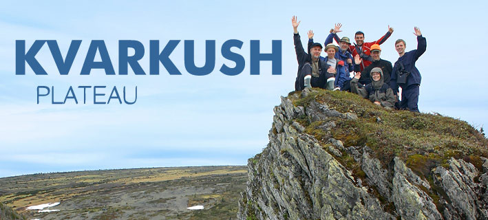
Next day we will climb the plateau Kvarkush and see the 10m high rocks - similar to those on the plateau Man-Pupy-Ner and visit the reindeer herdsman who lives at the foot of the Mt. Vogulskii Kamien – we will climb this mountain. From the plateau we will see unique natural landscapes of the northern Urals - typical mountain - taiga landscapes - scree slopes, the plateau in the upper region, foothills and low taiga.
Spend the night in the tents in the upper reaches of the stream Zhigalan.
The next morning we go downstream to the waterfalls where we will see one of the most beautiful places of the northern Urals. With a fall of approximately 700 metres over the 7 kilometres to its mouth, the Zhigalan is almost a continuous cascade of large and small waterfalls and a “wild” conglomeration of boulders.
Beginning on the east slope of the Kvarkush plateau, the Zhigalan flows in a deep, almost impassable “gloomy” canyon with high abrupt slopes, where snow remains the whole year round.
Only in the early morning sunbeams penetrate into the depths of this gorge. At this time it is unusually silent in the taiga - the only sound being the hollow rumble of a water stream. But when the sun, rising in the east, shines into the valley, the nature changes. Patches of light “play” in water streams, on leaves of willows and mountain ashes, “paint” the stones, covered with lichens, with bright colours – at this time “nature at its most beautiful best”.
Spend the night in the tents near where the Zhigalan flows into the river Uls. The river Uls, rising from the slopes of the main Ural ridge, flows in sub-meridional direction and then, after turning to the west, flows into the river Vishera. The biggest tributaries of the Zhigalan are Lyampa, Kutim, Pelya and Zhigalan.
From the mouth of the Zhigalan our rafting begins – along the rivers Uls and Vishera up to the town Krasnovishersk.
It is interesting to note, that in this area, many names of rivers, streams and mountains have as their basis the Russian word “Zolotoi” (Gold). There are many rivers “Zolotaya” and “Zolotikha”, mountains “Zolotaya” and settlements “Zolotanka”. These names are modern and are connected with the beginning of the development of numerous gold places in the region.
In comparison with the river Uls, the Vishera flows slowly. It is considered the most beautiful river of the northern Urals - its length is 415 km and its basin covers an area of more than 31200 sq. km. Earlier it was named "Passer-Ya", which means “Big Water” in Mansi language.
 The river crosses some of the pre-Ural mountain ranges “Kolchimskii”, (“Pomyanennui Ridge”) and others. On its banks there are limestone rock formations making very picturesque views. On both banks, the rocks “Ostantsy” rise - all having historical names - among them - “Kamien - Fighter”, “Pisanui Kamen” (painted rock) and “Govorlivii Kamien” (Talkative) with a height of 100 metres and others. The river crosses some of the pre-Ural mountain ranges “Kolchimskii”, (“Pomyanennui Ridge”) and others. On its banks there are limestone rock formations making very picturesque views. On both banks, the rocks “Ostantsy” rise - all having historical names - among them - “Kamien - Fighter”, “Pisanui Kamen” (painted rock) and “Govorlivii Kamien” (Talkative) with a height of 100 metres and others.
Near the town Krasnovishersk there are two mountains - “Polyudov Kamen” (Height - 527 metres) and “Kamen Vetlan”, situated on opposite banks of the river Vishera. Climbing the mountain “Polyudov Kamen”, a boundless sea of a taiga opens before us and the Ural ridge can be seen in the east.
We finish our tour at the town Krasnovishersk, from where we will depart.  
|