River Sakmara
The river Sakmara is the largest tributary of the river Ural. It flows from the slopes of the ridge Uraltau and is separated by the ridge Irendyk from the upper reaches of the river Ural.
To the south, bending around Zilair plateau, the Sakmara flows through a deep gorge and turns to the west. Its tributaries– Kasmarka and Bolshoi Ik flow from the Zilair plateau and the Salmysh - from the Obschij Syrt ridge. Having collected all its tributaries from foothills of the Urals, the Sakmara flows into the river Ural below the city Orenburg. The area of the river Ural basin before its confluence with the river Sakmara is about 79.6 thousand sq. km, and Sakmara - 30, 2 thousand sq. km. Nevertheless, the river Sakmara is more abundant in water than the Ural, as it flows from the rainy side of the Urals. The average annual amount if water discharged by the river Ural near the city Orenburg, is 3.3 cubic km, and the Sakmara – about 4. 4.
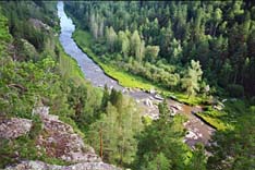
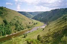
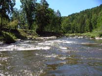
Sakmara’s basin is characterized by mountainous relief – basically a low mountain range, with the western part more flat and mixed forest. The river valley is steep and meandering, with the river flowing in “V” shaped valleys, deep gorges and between limestone walls. It is especially picturesque and it is possible to observe karst topography (karst craters, caves and others), connected with the carbonate rocks.
Summer in the river area is warm and humid - the average temperature in July increases from 17OC in the north up to 20 OC in the south. The annual rainfall ranges from 400 mm in the south up to 700 mm in the north.
In the upper reaches, the broad-leaved (birch) and mixed forests, consisting of birch, aspen and rare pines prevail. In the upper reaches of the river Bolshoi Ik – a tributary of the Sakmara - coniferous and broad-leaved forests are abundant. Pine, oak linden, elm, and sometimes maple are characteristic. In some parts of the region oak forests penetrate to the south to the valley of the river Sakmara (after railway station Kuvandyk). In the southern and eastern parts of the basin, steppe vegetation with small birch woods prevails.
The river was well known even in ancient times and in 1154, the Arabian geographer Al-Idrisi described it under the name “Magra” noting numerous finds of various precious stones in the river.
Our tours:
Rafting on the river Sakmara  
|